Introduction and Initial Choice of Alternatives
For hikers walking the entire alpine crossing, there are three ways to join the GR52 after Larche to reach Boréon. (Another page discusses the continuation on the GR52 out of Boréon. The first alternative is taking the link trail from Saint Dalmas Valdeblore on the GR5 to Boreon, (previously the official GR52 route), which will add two extra days of hiking over the GR5 on easier, less interesting trails compared to my preferred routes.
A second way to join the GR52, for easy going hikers, is to take the 8:30 am bus from Saint Etienne-de-Tinée or Auron (on the GR5) after night 2 out of Larche to Isola Ville, transferring to a bus (some buses require a reservation) or taxi (from Isola 2000) to Isola 2000, thus reaching Boreon on day 3 or 4, which will allow you to reach the Mediterranean one or two days faster than following the GR5. I suggest contacting the Tourist Office
The third alternative to reach Boréon is to join the GR52 just out of Larche. If you follow my recommendations it will not take longer than the GR5 to reach the Mediterranean, but if you chose a different route, it could take one to three days longer. This web page discusses this third alternative, that is called the “Balconies of the Mercantour”.
The Balconies of the Mercantour route, which has become the official GR52, was originally conceived to follow the alpine crest of the Mercantour Park entirely in France. However, it was never completed due to environmental objections. Consequently, this route requires excursions into Italy. The first half of the Balconies of the Mercantour route takes place in wild, pristine high-mountain country unique in an Alpine Crossing to the Mediterranean. The second half contains beautiful vistas, but is more civilized. The entire route is accessible to average hikers if snow is off the trail.
I give the Balconies of the Mercantour route, which I strongly prefer to the GR5, extensive treatment below, because I don’t believe you will find this route described in English anywhere else; and also, in 2024, it was not covered in a French topoguide. You should be able to judge from the pictures on this page whether the Balconies route is for you.
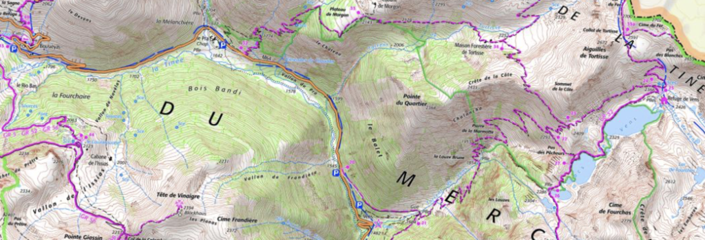
Since the GR 5 guide book maps do not cover this area. You should purchase the IGN maps 3639 OT “Haute Tinée 1” and 3640 ET “Haute Tinée 2” or print out your own maps from screenshots at geoportail.gouv.fr (use a IGN Topographic map from the Cartes/Fond des Cartes menu. and zoom way in to see the trails and elevations!).
The start on GR5:
From Larche the GR 5 climbs 1,000 meters to the Pas de Cavale in 4 hours of walking and descends approximately 300 meters to the Lacs d’Angel. There are 3 options after the Lacs d’Angel, and one easy-goer option that bypasses the GR5 to start in Italy:
A) Directly to the Refuge de Vens —partly without a trail, but not requiring special skills. This is the preferred route, with approximately 400 meters of additional climb and 300 meters of additional descent (total assent from Larche of 1400 meters and total descent of 600 meters).
B). Descending on the GR5 to Bousiéyas for a night (140 meters additional climb and 620 meters of additional descent), and the next day walking two kilometers down the road to le Pra at 1650 meters (or hitching a ride)(a 210 meter descent, and climbing to the Refuge de Vens at 2,466 (an 800 meter ascent) (or in a longer day going directly to the Refuge de Rabuons). This spreads the climbs over two days (total assent from Larche of roughly 1940 meters and total descent of 1130 meters).
C) Taking the GR52 (which these days comes in from the west) into Italy, overnighting in Ferrere, climbing the next to the Col de Fer, and then, as in Route A, descending on the GR52 to the Refuge de Vens. This is always on trails (except for a short easy shortcut from the Lacs d’Angel that avoids 150 meters of descent and climb on trails). However, it requires an approximately 9 kilometer detour with an additional assent of 1100 meters to the Col de Pouriac and an additional descent of 400 meters. (Total Ascent of 2100 meters and total descent of 1000 meters). There is lodging after the descent, in the tiny village of Ferrere (somtimes spelled Ferriere) (https://www.rifugiobecchirossi.com). I will not discuss this further as it is always on the GR52.
D)Easy goers, may convince somebody in Larche to transport them to Ferrere, Italy, on the GR52, about 20 kilometers from Larche. By starting on the GR52 in Ferrere, one eliminates the climb to the Pas de Cavale and the subsequent descent. Therefore the total ascent is 800 meters and the total descent is 300 meters, making it the easiest option. I will not discuss this further.
Since Routes A), C) and D) all cross the Col de Fer (Iron Pass), they should never be taken in cloudy or foggy weather or during thunderstorms!
Details for the GR5 from Larche:
Important: Ask at the Gîte de Larche about snow conditions on the Pas de Cavale (2671 meters, 8763 feet). If they tell you it is blocked with snow, as it may be into late-July (as was the case on my second visit), the same “Salse Moraine Valley” shown in the photo below and the GR5 there may be joined by a somewhat lower trail via the Col de Pouriac (2506 m, 8221 ft). The trailhead is in Italy, four kilometers southeast of the GR5 on the main highway from Larche. Figure that this detour will add an hour and one-half to your walking time, more if you have to contend with snow banks. If you are an easy going walker, offer to pay the gite owner or a hotel employee to transport you to the Italian trailhead by car, saving 3 hours. (Once at the Col de Pouriac, you can also follow Option C, descending to Ferrere.)
II highly recommend that you depart before 8am to be off the high and exposed passes before mid-afternoon. The Gite de Larche can prepare a cold breakfast. In general, from Larche to the Mediterranean, and especially for my Route A), it is wise to set off at 6 or 7 in the morning, to do your climbing before the sun is overhead.
You leave Larche by the highway and quickly branch onto a minor road, which, after an hour, curves southwards and enters the Mercantour National Park. Now on a trail, the GR5 climbs 1,000 meters to the Pas de la Cavale at 2,671 meters (8,763 feet) in a total of 4 1/2 hours (not including rest stops). Looking ahead from the pass of the Pas de la Cavale, the scenery resembles a moonscape.
From the Pas de Cavale

Notice the Lac d’Angel on left below. The trail to Bouziéyas runs from there along dried river towards the right.
The following photo is to the left of the one above, facing south-southeast, with a wider angle view. This is where you will be going if you are taking the A – Partially No Trail Route. You will be climbing along the black and green ridges running from the right to the center of photo; then, turning right, it passes out of view, before the mountains in distance. The green carpet is not trees or shrubery. The dot marks your intermediate destination. A trail starts further up.

Descend on the GR5 to the lakes d’Angel in the Salse Moraine Valley at 2,343 meters Looking back now at the Pas de Cavalle pass, you will wonder how you ever came down the cliff.
Looking back at the Pas de Cavale from Lac d’Angel.

|
Continuation Option A: Directions from the Lacs d’Angel to the Refuge du Vens
This route is fine for walkers — not steep or vertiginous — but for those not used to walking off trail, this route may be scary. Both times I walked the route, my companions felt completely lost because they could not see from below where we were going. Those using GPS may have a better sense of security. The very qualities that makes this route scary to some makes it one of my favorite routes. However, I do not recommend undertaking the route alone, because, in the unlikely event of an accident, you are not likely to meet anyone else on the way.
Needless to say, don’t attempt this route if there is the least sign of thunderstorms, or if thre is fog on the peaks; the “Col de Fer” on this route (and routes C and D) means “pass of iron”, and this pass is known to attract lightning hits. Also don’t attemmpt this route if your physical stamina is low.
Allow 4 walking hours from the Pas de Cavalle to the Refuge de Vens. This comes to about an 8 1/2 hours of walking from Larche (not including rest stops).
Stay left of the lakes. Descend to about 2200 meters (Appx. GPS: 44.3479 6.8954), crossing the dry river. At the bottom by the rounded ridges, bear left. Begin climbing below the ridges. Once you have passed by the top edge of the rounded ridge that will have blocked your view to the right, a series of little lakes, perhaps dry, becomes visible, and you will keep these on your right as you continue to climb, passing the uppermost little lake, and entering a sort of a mini-valley that has a trail in it, running off slightly to the right to the Pas de Morgon (elevation 2714, appx GPS 44.3328 6.9256 ). You are almost at the same elevation as the Pas de Cavalle.
Looking back during the climb. The little lakes are below towards left. Pas de Cavale, from which you came, located just left of middle of photo. The Italian pass, somewhat lower, is visible almost straight ahead. We are now on a faint trail.

Soon the trail is on a ridge, slightly exposed on both sides, following cairns. At the end of the ridge, where in poor visibility you can feel lost, the trail turns sharply right by about 135 degrees, angling backwards down the slope, and at the bottom turn sharply left again on a faint trail that soon meets another, better and waymarked trail that comes up from the right and soon another, the GR52, from the left at the Col du Fer, 2,684 meters (44.3380 6.9157′). Continue to the Collet Tortisse , 2591m (44.3228 6.9369). Now descend to the Refuge de Vens, at 2,366 meters, 7,762 feet, on a lake of the same name. This is one of the wildest corners of France.
View from the trail of the Refuge and lake of Vens.

Continuation Option B:
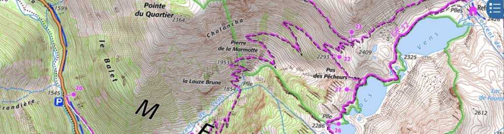
Descend on the GR5 to the gîte d’étape at Bousiéyas and spend the night there. On the following day walk down hilll on the highway for 2 kilometers to le Pra. Then, before and above the parking, take the trail (marker 32) which leads up to the Refuge de Vens (2,426 m) in four hours. If you come to Vens via this route through Bousieyas, it adds a day to your trip. But you could choose to skip Vens and walk directly to the Rabuons refuge, in which case you do not lose a day (total walking time from Bousieyas to the Rabuons refuge is at least 8 hours). See the following maps. (If going to the Refuge du Rabuons, note the shortcut , from (23) to (22) (a descent of 100 meters) and then a 50 meter ascent and descent to (27) (on the map for day 2).
From Pra to Vens or towards Rabuons
Closeup of the connection towards Rabuons.
Day 2: Continuing from the Refuge de Vens to the Refuge de Rabuons on the Balcons du Mercantour route.
(Note: If you wish to return to Nice or regain the GR5 you can do so by descending from the Refuge de Vens to Saint-Etienne-du-Tinée. To do so, following trail signs, climb 300 meters (1,000 feet) and descend 1300 meters (4,000 feet) in about 4 1/2 hours).
The map below, up to date at this writing (2023) shows the route from the Refuge de Vens (25) to the Refuge du Rabuons (105).

From the Refuge du Vens (signpost #25), the trail passes along the north side of the Vens lakes. Make a brief detour to see the view where a stream exits to the lip of the plateau. Then, after passing another lake, climb over a pass. After the pass bear left and climb slightly onto the Chemin de l’Energie—a true road (but with no way to drive to it) built between the World Wars to permit construction of a hydroelectric plant (that never materialized). About 5 kilometers long and practically level, the Chemin continuously has excellent views of the Tinée valley until, near the end, it passes through two tunnels. (An extra climb and descent is necessary to detour via the Plan de Tinebre, as shown on the map, if the repairs to the tunnels have not been completed.) Climb again briefly to the Refuge de Rabuons (tel.04 93 23 04 11) at 2,510 meters, located beside a lake and sourrounded on three sides by foreboding mountains of black rocks. The Rabuons refuge is isolated, basic and small, but has a wonderful ambiance, a solar shower, and cheerful service. (See the refuge on its “rock” two-thirds to the left on the second photo below.) Walking time from the Refuge de Vens is 4 hours.
There is a high route from Vens over Mount Tinebre to Rabuons for mountaineers —quite exposed and difficult, that usually requires crampons and ice ax. Check with the staff at the Refuge de Vens if you are a mountaineer.
Tunnels on the “Energy Road”, seen from the trail to the valley.

Days 3 and 4: Continuation of the Balcons du Mercantour Route (now the GR52) to Refuge Laus and Sant’ Anna, in Italy, or possibly continue further to Isola 2000
| From the Rabuons refuge (2,523 meters), if you should wish to rejoing the GR5, you can descend to St.-Étienne-de-Tinnée (1,300 meters – 4,000 feet) in under 4 hours. |
Day 3:
You can walk this section from the Rabuon refuge: (A) on walking trails (mainly the GR52) or (B) on mountaineering trails.
On day 3, A) Walking: You can take the recently opened (fall 2008) route, lower in altitude (highest point about 2650 m), but longer in distance and time, trail to the Laus refuge. It involves an assent of approximately 130 meters (400 feet), a descent of 500 meters (1,600 feet), another assent of 400 meters (1,300 feet), and another descent of 650 meters (2,100 feet). This would take 6 or so walking hours.
Or, on day 3, B) Mountaineering : If (big if) the snow is off the Corborant pass (3007 m – 9,900 ft), AND you are willing to use your hands a bit, AND if you are willing to descend a scree slope, AND if you are willing to climb 500 meters (1,500 feet), descend 1,400 meters ( 4,600 feet), and climb again 300 meters (1,000 feet) you can take the Corborant pass to the Alexandris Foches (Laus) Refuge in about 5 or so hours not counting stops.
On day 4: A) Walking (the GR52): You can take the easy low route to the Sant’ Anna Sanctuary in 4 hours and perhaps even continue to Isola 2000.
On Day 4, B) Mountaineering: There is the exciting crest route that involves walking on a slanted hillside where a slip would be very bad and the crossing of a narrow, exposed pass with a 300 meter drop:
Details on Day 3 Option A) Walking option:
Refuge (on left) and Lac du Rabuons looking back from new trail .

In the summer of 2009 I used the newly created trail now visible on tab.geoportail.gouv.fr (click the list of “donées” to add the IGN maps) and on the recent IGN paper map of the area. It runs southeast along the French side of the crest. I can recommend this trail for average walkers provided all the snow is off the trail. Ask at the Rabuons refuge if the trail is clear (in a normal year by mid-July), making very clear to them your level of skill. The guardian, being a mountaineer, as in most refuges, is likely to assume that it is easy to go around snowfields by climbing up and down the rocks (which is what I did), or to hack out steps to cross them. If there is snow on the trail, descend to St. Etienne-de-Tinée, and either follow the GR 5 or if you are not a “purist”, take a bus or a taxi to Isola 2000 and pick up the trail there, saving a day or two.
View from the new trail towards Auron village across the valley, where the GR5 passes, 1000 meters (3,300 feet) below this level . The GR5 is visible climbing from Auron, center-left.

The new trail is wide, about one-half the width of a road lane. From Rabuons it climbs to the south, crosses a col, and contours around a bowl (see photo immediately below), all over slabs of rock and stones.
The rock-filled bowl below. Trail climbs uphill on the right.

This portion is slow going, taking about 2 hours, as you much watch your step .
Leaving the bowl, the trail is in normal grass and you can double or triple your speed. Another hour bring you to a signposted cross trail . If bad weather has suddenly rolled in, you can descend to Douans in the valley (1100 meters below). Otherwise, turn left and climb to the Pas de Colle Longue at the Italian border.
The gardian of the Rabuons refuge warned me not to take any of the other trails to Italy indicated by dashed lines on some maps (but not easily visible from the new route), because they have not been maintained and are quite dangerous.
Climb to the Pas de Colle Longue

The climb from the above-mentioned trail junction takes a good hour, mostly through beautiful rolling meadows full of sheep. There is only one short somewhat exposed portion of the trail where you must watch your step. At the col one sees the remains of military fortifications and barbed wire. You spot the Lake of St. Bernalfo (but not the village), which is near the refuge, 650 meters below the pass, about an hour and one-half by the sinuous closed-off road and/or the partial trail. I saw three chamoix in this valley. The refuge is five minutes to the left of the lake, just over the crest of a hill on the road (Tel Italy (39) 0171-959-606). The refuge is open continuously during July and August and on weekends from May to October. When the refuge is closed, it may be possible to use a matress in the winter bivouac room, if you are carrying your own food. Call for details and reservations. Figure about 6 hours in all from Rabuons. You should should strongly consider spending the night at the Refuge Alexandris Foches at Laus.
Refuge Alexandris Foches at Laus

Since it was mid-week in July, I had a room with four bunk beds for myself, and never met anyone in the bathrooom. The meal consisted of four courses: pasta; meat; cheese; fruit.
Day 4: From Refuge Laus to Sant Anna:
It is possible to combine this day with the next one to make one long day of 7 or 8 hours from Laus to Isola 2000.
Santuario Sant’ Anna di Vinadio (tel. Italy (39)0171-959-125 https://www.santuariosantanna.eu/en/), your destination, is a sanctuary for travelers, a place of worship, and a famous pilgrimage destination in Italy. The sanctuary was founded hundreds of years ago to serve travelers and thus also runs what amounts to a hotel and also refuge. It was nice for a change to have sheets, large towels and my own bathroom, and to enjoy watching the mixture of pilgrims and tourists. The menu at Santa Anna was similar to the night before, three courses – typically pasta followed by meat and vegetables, followed by dessert. Santa Anna has a separate snack bar open at lunch with sandwiches, pies and drinks. The beautiful church there is poised on a rock slap, and its floor slants up to the altar.
Details on the two ways of going from Laus to Sant’ Anna:
A) The route for regular walkers from the Laus refuge to Santa Anna (GR52):
The last few minutes to Santa Anna are on a tarred road.

This route involves going down to Callieri, (a descent of about 450 meters). From Callieri the trail leads directly to Santa Anna via the Tesina Pass (a climb of 1,000 meters and a 400 meter descent). This 4 hour routing, though unexciting, is attractive, easy and safe.
If you are are combining this day with the next one, you will save almost an hour by not descending all the way to Sant’ Anna.
B) The exciting, risky, crest route near the French-Italian border: In 2009 I took the crest route from Laus, which involved climbing up to the Paso del Bue (Pas du Boeuf) (Beef Pass) (a climb of 700 meters from Laus). Average walkers: avoid this route; you must be sure-footed, very careful, and willing to undergo exposure to heights.
Since my use of this trail was 15 years ago at this writing, be sure to check with the Laus Refuge if the trail is safe!!!
The trail to the pass was badly maintained in several places, and required walking several hundred meters (yards) in footsteps on a steeply sideways-slanted hillside. In other words, it was a bit dangerous and absolutely required fabulous balance or trekking poles! The Paso del Bue is narrow and quite exposed (see photobelow).
Looking back (down) from the Passo del Bue (Pas de Boeuf) (a military building on a snow patch is visable as well as the trail on the hillside and over the snow)
Passo del Bue


After the pass, the trail continues over slabs of rock and stones for about 1 mile before reaching dirt. In the photo above, the trail runs about one-third of the way down the slope just beneath the cliffs, and turns right into a gap in the ridge. Some maps show a trail along the very crest between France and Italy, but the Laus guardian told me that this was very dangerous. The correct trail shown in the photo is now on the Geoportail site and on recent IGN maps.
At a branch in the trail in view of a stone military building, a direct trail to the left leads towards the pass, but it looked eroded and dangerous; I chose to go to the right, scrambling up an eroded slope to a better trail that went in front of the military structure. From there, after a flat stretch, it takes some scrambling up steep somewhat slippery slope on an eroded but safe-enough trail to the Paso Saboulé. From the pass, you can choose between two very good trails is to Santa Anna. The shorter route, by perhaps one-half hour goes left to the Passo Tesina. The longer route crosses into France, passes by some nice alpine lakes before crossing back into Italy on a road carved steeply into the mountainside (here I saw two bouquetin), and descends by a closed-off unpaved military road from WWII to Santa Anna. Total walking time is about 6 hours. The mountaining route described above, while exciting, should only be taken by those equipped with trekking poles, and who are wiling to undergo a degree of risk, exposure, and difficulty, and not by the average trail walker. Again, please check if the trail is still viable.
Day 5: From Santa Anna to Isola 2000 (or Boréon)
An steep but safe trail (GR52) leads from Santa Anna up to the ridge line in one hour, and then in another hour to the Col de Lombarde, above Isola 2000. If the weather is inclement, or, if you wish shade, you can walk up the military road in the valley in even less total time by descending from Santa Anna on a trail to a track that eventually joins the main road, and then bypassing the road switchbacks to reach the Col de Lombarde (2350 meters). Depending upon your route, the total climb is 250 to 350 meters. The descent from the pass to the ski village can be accomplished in less than an hour by the ski slopes, or perhaps in an hour by a marked trail that winds over scree before descending. Total time is under 3 hours.
Isola 2000. Straight ahead is the Col Mercière, your continuation

As the name indicates, Isola 2000 is at an altitude of 2000 meters. This ski village, like Auron on the GR5, has a number of unattractive buildings that may offend many hikers who prefer infrenquented pristine areas. There are only two hotels in Isola 2000: the Hotel Druos ** in summer almost always has last-minute nice rooms without board at a reasonable price; the Pas de Loup***, less available, includes all meals. There is no gite d’étape or refuge. The restaurants, such as the popular La Marmotte or La Raclette, specialize in alpine cuisine, but also serve traditional French cafe dishes. The hotels in Isola 2000 are connected together side by side, and under them can be found a continuing passageway – shopping mall. Walk through the mall and you will come upon the market, shops and restaurants Most stores will be closed on Sunday and from 12:30 to 3:00. There is bus service to Nice.
Many walkers who have stayed in Sant’ Anna may prefer to continue directly to Boréon in one fairly easy day of 7 hours. By taking the trail to the left from the road after the ski lift crossing and branching off left at trail marker 91 you can save 100 meters of descent, bypassing Isola 2000.
Day 6: From Isola 2000 to Le Boreon
For those who wish to spend a week on the GR52, a Lignes d’Azur bus on line 750 leaves at 10:15 AM (2024) from the bus station in Nice and arrives at Isola 2000 in 2 hours. A pleasant walk will put you in Boréon by late afternoon. It is also possible to reach Boréon directly by bus on Lignes d’Azur #730 from Nice, departing at 8:15 or 9:15, to St. Martin-Vesubie,arriving at 10 or 11 AM, and then transfering to a shuttle (navette) to Boræeon, or take a taxi to Borón or to Madonna de Fenestre.
If you wish to spend an extra day among high peaks and lakes, you can stay on the GR52 out of Isola 2000. It goes back into Italy. Your climb from Isola 2000 will be 600 meters to the Baisse du Druos and a 300 meter descent to the Rifugio Questa. The next day requires 350 meters of climbing to the Col de Fremamorta and a 11oo descent to Boreon
It takes just over an hour from the Isola 2000 village to climb to the Col de Mercière at 2,343 meters. From there in summer you can descend through the fields, cutting off the curves of the sinuous dirt road that forms the official trail, until you reach the lovely pine, larch and fir forest.

You walk easily through this enjoyable forest on a dirt road closed to traffic, first descending, then almost keeping level, for 1 1/2 or 2 hours until the Col de Salesé (2031). Just before the col you meet and join the GR52. You are now off the Haute Tinée 2 map and on the Vesubie map, but on the GR52 map if you are using a French Topoguide. In any case, the route is signposted and waymarked. From the col you descend on a highly trampled trail to the Parking area in 1 hour, and then by the tarred road to Boreon (1526 m) in another 1/2 hour. Total time from Isola 2000 is 5 to 5 1/2 hours.
A wolf sanctuary in Le Boreon—containing about 20 wolves—may be toured in a couple of hours. Le Boreon has a pleasant lake, much visited by tourists for the day, and a restaurant serving trout you are supposed to catch yourself (but they bend the rules). There is at least one hotel and also in a Gite d’étape, as well as bus service to Nice. As you are now on the GR52, covered in detail in a topoguide, so my detailed trail description ends with Boreon.
Summary
The Balcons du Mercantour trails described above are worthy of your strong consideration. They provide the stark beauty of a truly high level route; the excitment of some more difficult trails—if you choose them; the novelty of an excursion into Italy; and a savings of one or two days walking time if you are continuing on the GR52
The GR52 from Boreon to Menton |