Possible GR5 Starting Points on the Lake Geneva (Lac Leman) south shore, including the author’s more enjoyable and easier unofficial route.
 Introduction:Lac Leman (Lake Geneva), the largest natural lake in Western Europe, lies at an elevation of 374 meters (1,227 feet). Beautifully green mountains and hills surround most of the lake. French speaking Geneva and its airport lie at the southwestern tip of the lake. Those walking southward on the entire GR5 will come to Lake Leman at Nyon on the north- western shore. Cruise boats cross the lake from Nyon, Lausanne and Geneva, and permit access to points on the south shore, including all trailheads for the GR5 southbound. For schedules, contact http://www.cgn.ch/. Frequent Swiss trains connect to Geneva and other north shore points: http://www.sbb.ch/en/, and frequent French trains http://voyages.sncf.com connect Geneva to south shore points such as Thonon-Les-Bains and Evian-Les-Bains. Since the GR 5 is normally only one trail, when there is more that one trail connecting two points, normally the extra trails are called variants and are numbered 5a, 5b etc., or, are given a different number beginning with 5 such as 52 or 56. This normality is broken by the start of the Alpine crossing on the south shore of Lake Geneva: The two starting points are both labeled GR5. Having hiked one of these routes and studied the other, I recommend yet another, unofficial, lake-shore starting point between the two. I hiked that route the second time I walked this section of the GR5. I’ll cover these alternatives in turn, but first I must deal with an issue common to all of them. When I refer here to hiking times on this page, I am using the timescale found in the French Topo Guides – climbing at 300 meters (1000 feet) per hour and walking 2.4 (kilometers per hour (1.5 mph) on the flat. The climbing rates from the starting points in the “GR5 Trail” guidebook by Paddy Dillion are in my estimation too high for typical walkers (especially since most walkers will be starting their hike at Lac Leman), as they are based on climbing at 400 to 500 meters an hour.
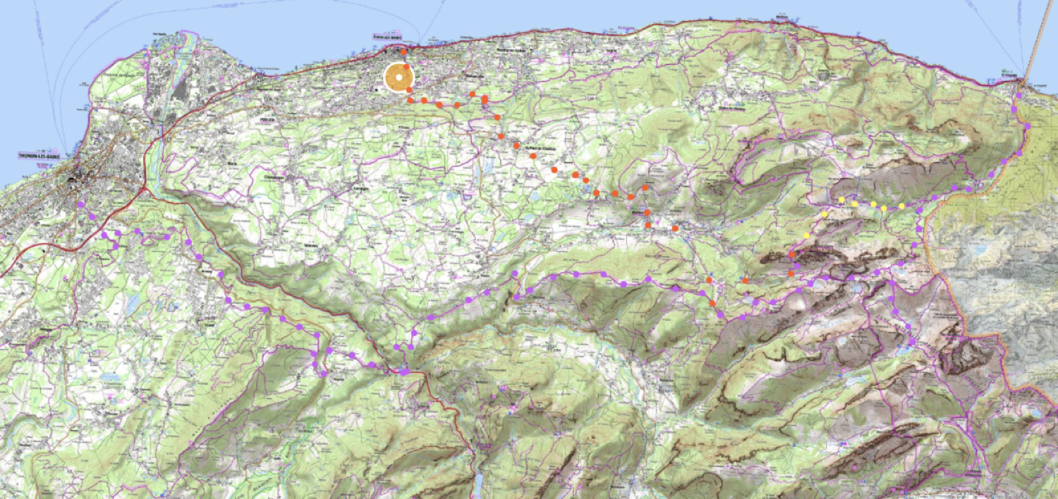
The Three Starting Points:Thonon-les-Bains starting point From this starting point it will take most hikers three days to reach La Chapelle d’Abondence. One GR5 starts from Thonon-les-Bains, a resort town, easily accessible by train from Geneva or Paris, and also by lake steamer from Nyon, Lausanne or Geneva. It will take you approximately 12 1/4 hours (without counting rest and meal stops) to walk from Thonon to the junction with the other GR5. To find lodging the first night, you will need to detour from the GR5 to one of the refuges or hotels at Les Clouz, Vinzier or Chevenoz (respectively 5/1/4, 5 1/2 or 7 hours from Thonon). Thus, your total walking time to the junction of the other GR5 coming from St._Gingolph will be about 13 hours From this junction, another 3 1/2 to 4 hours will take you to La Chapelle d’Abondance, where there are lodgings of all types, including many hotels. If you were to attempt to reach La Chapelle d’Abondance, in two days, you would have to walk 7 hours the first day and 9 or 10 hours the second, which on the second day would include a 1,100 meter (3,600 feet) ascent and a 900 meter (2,900 feet) descent. On this route from Thonon-les-Bains, the refuge of the Dent d’Oche can be reached in 13 hours, including the detours for lodging.. The walk from Thonon-les-Bain has some views of the Drance river and occasionally of Lake Geneva. Mostly, however you are in a depression with limited views. After an initial slow climb, you descend to cross the Drance river, then climb again and stay relatively flat until Le Crêt. The first day you ascend in total about 600 meters (2,000 feet). The second day, assuming you are not going all the way to La Chapelle d’Abondance, you ascend 1,100 meters (3,600 feet) to the trail’s high point at the Col de Bise (or another 350 meters – 1,150 feet to the Dent d’Oche. That second day may be daunting for hikers not fully conditioned. St.-Gingolph starting point From this starting point, it will take most hikers two days to reach La Chapelle d’Abondence. The second GR5 starts from a tiny commune that straddles the French-Swiss border, St.-Gingolph—a town with only a few services and without much charm. Lodging is in modest hotels in the French part of the town, or in a fancier hotels in the Swiss part of town. For hotel contact information visit: http://www.st-gingolph.ch/. If you are conditioned, this route will save you one day of walking. Access by public transportation is possible by taking a morning train to Lausanne (which, incidently, is from Paris the fastest lake access point), taking a taxi to the Lausanne-Ouchy dock, and crossing the lake on a cruise boat. It is also possible from Geneva to take a train or cruise boat to Evian-les-Bains, and then a taxi or a bus on line 131 ( http://www.sat-leman.com/img/os_document/885_ligne_131_thonon_saint_gingolph_du_13122020_au_11122021.pdf ) for the 17 kilometer (10 mile) trip to St. Gingolph. A few trains arrive in St.-Gingolph from Monthey, which is on the Lausanne-Martigny line, if you are coming from points east. The GR5 trail from the lake continuously ascends very steeply up a viewless ravine for 5 hours (if your physical condition permits!) to the junction point with the other GR5 coming from Thonon-Les-Bains .. The elevation gain to the Col de Bise pass is 1,500 meters (4,900) feet if you are staying on the GR5. If you are going to the Dent D’Oche, it ascends about 1,850 meters or 6,070 feet. Because of the tremendous effort that may be required on the first day’s climb, many hikers may prefer, on the afternoon of their arrival in St.- Gingolph, to hike up to Novel, 2 hours i.e., some 600 meters (2,000 feet) above the lake. As of this writing in 2020 there is a new hotel-restaurant, opened in 2017,: https://www.les-chemins-du-leman.com A side trip from the GR5 to the Dent d’Oche, which I highly recommend in good weather for its stupendous, unforgetable view of Lac Léman, requires a 6 1/2 hours climb from Lac Léman. The times given above are the book times that assume that you are already in good shape. On my first trip on the GR5 from Lac Léman, (without full understanding and only in fair shape) I undertook this 6,070 foot ascent from the lake shore to the Dent d’Oche in 8 exhausting hours. In order to go to the Dent d’Oche from Saint-Gingolph, one should branch off to the West onto the Balcon de Leman trail, which leads directly there without a major loss of altitude. (If one followed the GR5 to the junction from the other GR5 starting point, and then took that trail to the west, one would walk and extra 2 kilometers and descent and re-climb an extra 300 meters.) Evian-les-Bains, my unofficial, prefered starting point From Evian-les-Bains it will take average hikers three days to reach La Chapelle d’Abondence. Lying midway between the two official GR5s, Evian is the starting point I prefer. It is obviously unsuitable for those who wish to say that they have walked “The GR5”, but just fine for those like me who wish to say that they “walked on or nearby the GR5 from Lake Geneva to the Mediterranean”. I prefer this route for three reasons: because Evian is charming; because, on the way, one has wonderful views of Lake Geneva and of highly attractive countryside; and because one can stay in a hotel or b&b the first night (but not a gite or refuge). This route takes about 4 hours less than the Thonon-les-Bains GR5, and 4 hours more than the Saint-Gingolph GR5. Detailed maps of the route follow after the description. Access to Evian — a town with considerable charm — is by train from Geneva or Paris, or by lake cruisship from Geneva, Nyon, or Lausanne.  To begin your alpine traverse, you climb for an hour on a waymarked route from the railway station, leading above the town, partly by a track, and then walk briefly east, parallel to the lake, with excellent views. You cut inland, not on trails but on countryside lanes, to a hotel of your choice in St-Paul-en-Chablais – Bernex area at about 950 meters (3,100 feet) elevation (2,000 feet above the lake) in about 3 1/2 to 4 1/2 hours of walking. An excellent website for researching hotels, B&Bs and lift hours in the St-Paul-en-Chablais and Bernex area is summer.bernex-tourisme.com. Some hotels sell out or require long stays, so I recommend calling your choice of lodging if you cannot reserve over the Internet. We enjoyed very much our stay at the Hotel Bois Joli** (St- Paul-en-Chablais address but near Bernex). In the photo below, on the plateau above Lake Leman, the Dent d’Oche is visible in the distance.
On Day 2 of this itinerary you have several choices. We did not enjoy the route we took some years ago, so I now recommend the shorter and easer routes following the road from Bernex . (A) If you are planning to go all the way to the Refuge de Bise, I suggest that you climb up the trail from elevation 988m along the Telesiège de Pré Richard (chairlift) to its top station at elevation 1338 m, and then continue up to the GR5 at 1508 m. The GR5 climbs steeply to 17772 m and then more gradually to a pass at 2069 m, before descending to the Refuge at 1500 meters. Thus it will be altogether an 1100 meter climb (3,600 feet) and a 500 meter descent (1700 feet), and about an hours worth of relatively flat walking. Perhaps it is a 7 hour day without stops. Easygoers can take the télésiege (chairlift) of Pré Richard (operational daily from the end of June until the end of September (perhaps on weekends in early June), weather permitting, from 10:00 AM to 5:15 PM for around 5 or 6 Euros) and walk from the top station, saving a climb of about 400 meters. (B) If you are going to the Dent d’Oche refuge, which I highly recommend in good weather, I suggest that you continue up the trail and then the road to La Fétiuère at 1215 meters. Easygoers may take a taxi to the parking lot at La Fétiuère, saving a climb of about 250 meters plus time on the flat…thus more than an hour. You could also take this route directly to the GR5 and the Chalet de Bise, but the views will be much more limited than the route suggested above. The Dent d’Oche refuge is at 2113 meters, so the total climb is about 1,150 meters (3,800 feet). The total time, without stops, to reach the Dent d’Oche should be about 4 to 5 hours. Day 1: Routes from Evian-les-Bains to Bernex: Day 2: Suggested routes from Bernex to the GR5 or to the Dent D’Oche :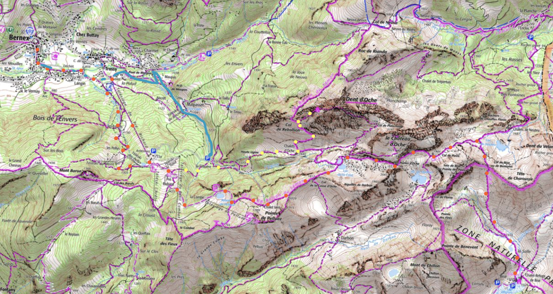 The issue of where to stay before La Chapelle d’Abondance:No matter which starting point you take, you will have to choose (on the second day from Thonon-les-Bains or on the first or second day from Saint-Gingolph) or the second day from Evian, whether to push on in a very long day to La Chapelle d’Abondance (without stops) 9 hours from Saint-Gingolph, over 10 hours from Chevenoz or Bernex), or to stop at an intermediate point. At the Col de Bise The Refuge de Bise has reopened http://refugedebise.com, and has 44 sleeping places. They can prepare meals or you can self-cater. It is a 300 meter (1,000 foot) climb plus an 800 meter (2,600 foot) descent. Thus it will take about three hours. If coming fromSt Gingolf via Novel, 600 meters above the lake (see details below). From there the hiking time the next day to La Chapelle d”Abondance to 7 hours. Another logical intermediate lodging if coming from the lake or Chevenoz is the Dent d’Oche Refuge at 2,114 meters (6,935 feet) (6 hours roughly without stops from either Saint-Gingolf or from Chevenoz if you are in great shape, 4 to 5 hours on the Evian-les-Bains route). This is a full service refuge with an incredible view over Lake Geneva (Lac Leman) and to Mount Blanc in good weather. In bad weather it would be unwise to visit. Since it is at high altitude, the meal choices are limited, but the food is fine. Getting there involves climbing an extra 300 meters, the last of part of which is somewhat steep, and involves using ones hands a bit. There is a chain to hold on to on the steepest part. If you have acrophobia, don’t go to this refuge. However I have seen young children and grand parents making the climb without a problem. From the refuge, for those with remaining energy, there is a 100 meter climb to the summit towering above. Allow 6 or 7 hours without stops to reach La Chapelle d’Abondance from the Dent d’Oche. My own visit to this refuge remains a visual high point of all my hiking. View over Evian-les-Bains and Lake Geneva from an outcrop near the Dent D’Oche.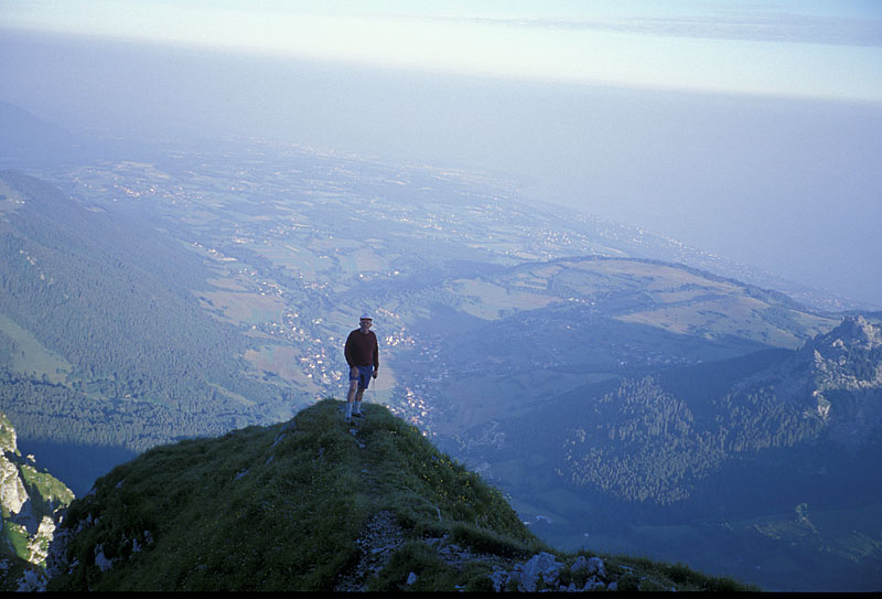 Looking south to Mt. Blanc from the Dent d’Oche: Next page: La Chapelle d’Abondance to Chamonix
|