| The GR 5, which mainly corresponds with the Europe 2 (E2) route, is perhaps the premier long distance hiking trail of Western Europe. GR stands for “Grande Randonnée”, which in French means literally a great hike, or in practice a long distance hiking trail.
The GR5 begins at Hoek van Holland on the North Sea, and ends in Southern France at the Mediterranean. It joins together many previously existing hiking trails, and a few new sections. It is laid out to traverse along, or to cross as many mountain ridges and highlands as possible—in Belgium, the Ardienne mountains; in Luxembourg, the hills by the rivers; in France, the Lorraine plateau, the Vosges Mountains of Alsace, the hills and gorges of the Jura, and, as the icing on the cake, the central spine of the Alps along the border between France and Switzerland, and further south , France and Italy. The Europe 2 (E2) hiking route extends the GR5 northward by, at present, beginning in Scotland, crossing England, and picking up on the European mainland. The eastern route in England picks up at the beginning of the GR5. The western English route picks up at Ostend, Belgium, and soon joins the GR5.
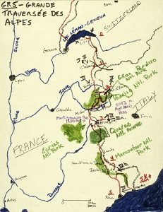
One cannot really compare the GR5 to the Appalachian trail or the Pacific Crest Trail. The GR5 passes through several countries. It visits many more villages and towns, and lies on the doorstep of some others with great tourist interest. GR5 hikers normally stay in huts, lodges or hotels rather than in tents. The experience is more social and civilized; the cost is somewhat higher. Everybody (almost) walks the GR5 from the north to the south. Probably, this is because they want to be walking from the the cold, rainy, grayer weather of Holland to the warm, dry, sunny Mediterranean; and also, to finish up their trip with the excitement of the Alps and a Mediterranean arrival. (Considering walking south to north? Please see this discussion.) This Site: The Alpine GR5, from Lake Geneva (Lac Léman) to the Mediterranean.This Internet Site primarily covers the Alpine GR5 – 52, from north to south, as it crosses through the highest part of the French Alps, along the borders of Switzerland and Italy. I do include some information on the entire GR5, that is, where to get guidebooks and maps, and how to read them. Characteristics of the GR5 in the AlpsThe GR5 is Arduous, but Ever-ChangingRivers draining the French Alps along the Swiss and Italian borders flow to the west, that is, across the grain of the north and south running GR5. What does this mean for you? It means that you will experience long ascents as you climb from the river valleys up to the high passes, and long descents as you hike down to the next big river. Passes traversed along the GR5 – GR52 are at 6,000 to 10,000 feet (1,800 – 3,000 meters), but the river valleys crossed can be as low as 1,500 to 3,000 feet (400 – 900 meters). These vast ups and downs mean not only that you, the hiker, will have a difficult walk, but also that you will traverse and see a great variety of beautiful scenery and different ecosystems—from pastures to woods to sub-alpine meadows, to glaciers. In the lower lands you will visit villages full of life, while in the heights you can be completely remote from civilization. Red arabic numbers below indicate weeks.The roman numerals refer to my first trips along the GR 5 and 52.
The through hiker of the GR5 Alpine Traverse also will experience an even greater variety of scenery due to decreasing rainfall as one walks from north to south.. The hillsides of Chablais, rising above Lake Geneva, are a lush green; and dairy cows graze by the trail as it passes through Switzerland. On the other hand, in the south, on the GR52 variant of the GR5, you pass through the Vallée des Merveilles (Valley of Marvels), of strikingly sculpted bare rock, without vegetation. In between these extremes, near Briançon, you l traverse beautiful semi-dry woods of larch trees, and alpine meadows of tiny rhododendrons. On the dorstep of the Mediterranean, you visit still another zone, where rain falls in a temperate climate, protected from northerly winds by the high Alps that you have crossed. The sparse Mediterranean maquis shrubs, and the lush hillsides of semi-tropical plants dropping down to Menton, are a delight to the eye after the arid country further north. Solitude and Wilderness? On a sunny day in the northern Alps, solitude on the trail is rare. People live in the northern Alps, or visit, much more often than in the mountains further south. The northern Alps are more easily accessible to the population centers of Europe, and are much more fertile. In the northern Alps there is no wilderness. Villages, chalets and pastures lie close by one-another. The Vanoise National Park is natural and wild, but still close-at-hand to civilization, and certainly full of hikers. None-the-less, except in the tourist towns, you can feel on your own. It is rare to see hikers in front of you or behind you on the trail, but you probably will pass day hikers traveling in the opposite direction several times an hour, or several times a day. In contrast, in the southern Alps hikers are few and far between. Parts of the high and arid Mercantour Park are as wild and isolated as you can get in France, and might even be called a small “wilderness”. Through these wilder areas in the southern Alps, particularly before or after the main hiking season, you could go all day without meeting another person. It is now almost 25 years since I first wrote this web site. Where I am aware of changes, both from walking and from reading, I’ve updated the site. However, as always, guide books have the latest routing, and now the Internet is full of information. Mass tourism has overrun Europe and most of the rest of the world, and the northern Alps are more full than ever. The region around Mount Blanc is most famous internationally, and surely the most crowded. In Chamonix hundreds and hundreds of hikers, many from the Far East,start the Tour of Mount Blanc (TMB), which overlaps for two days the GR5. Moreover, on a weekend hike to the Col de Tricot, there was a “race”in which many hundreds of hikers were crossing the col. I was told these “races” were frequent on weekends. As before, in the southern alps trails are almost empty. In the northern Alps it will be wise to reserve lodging as early as possible. Exposure There is no severe exposure on the main route of the GR5 or GR52, except perhaps the slightly slanted snowfield and short ladder on Brevant, which can easily be detoured. That said, as in all hiking, you will need to watch your step. If you decide to take certain GR5 variants or certain of my special routes you can experience some vertiginous passages, but these are mentioned in the descriptions and are not on the main trail. Wild animals It is quite possible to see several types of wild animals— at least I have on my trips: Chamois, Bouquetins ( Ibexes) , several types of deer, many kinds of birds, and the ubiquitous marmot. When to GoJuly, August, and September! See the page that discusses this in detail How long does the Alpine Crossing take? You can walk comfortably from Lake Geneva (Lac Léman) to Nice on the GR5, with a few rest days and a few extra days in Chamonix, in about five weeks; many hikers who walk longer days and don’t stop for recreation have done it in four or less. Depending on your route choices, you may need an extra two or three extra days for the more spectacular finish at Menton. Depending upon your routing, you will cover about 700 – 850 kilometers (420 – 510 miles). You can easily divide your trip over several years. This site gives information on break points, and how to reach them (see this page). My Terminology for Types of Trekkers – “Purists and Easygoers” The “Purists” are people like myself, who want to feel proud that they walked “every inch of the way” from Lake Geneva to the Mediterranean. Some purists may feel they have to do this only upon the trails officially designated as the GR5, or the GR52 (or GR 56 in the Vanoise Park). Other “purists”, like myself, take pride in deviating from the official trail, but still walking “every inch of the way”. “Easygoers” (like a number of friends who came along with me on some parts of the GR5) feel they don’t have to walk every bit of the trail. If the day is too long, if the trail is less interesting, or if the climb or descent is too arduous, they turn to motorized transport: possibly they hitch a ride, take a bus or taxi, or use a télépherique (i.e, a mountain lift). This site is written from the point of view of a purist—but not a purist who sticks only to the GR5,GR52 and GR56— but I also include some suggestions for easygoers. |
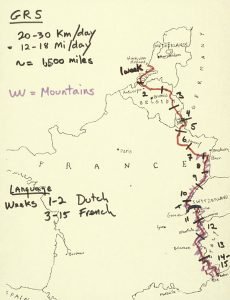
 The GR5 is about 1,500 miles long (2,500 kilometers). Three and one-half months of walking time are required for an average walker to “do” the GR5. But if you walk this far, you should really take the variant of the GR5 called the GR52, which leads to Menton on the Mediterranean in a couple of extra days, rather than the GR5 itself to Nice. The GR52 provides a much more spectacular finish.